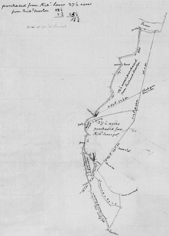
Survey and Plat for Land Purchased from Richard Overton, [on or after 31 August 1802]
Survey and Plat for Land Purchased from Richard Overton
[on or after 31 Aug. 1802]
1802. Aug. 31. courses run by mr Fitch.
Beginning in the road in the Thoro’fare at the crossing from Monticello to Montalto, and running on the West side of a fence which runs on the level of the Thoro’fare.
| N. 12. W. 12. po. |  |
so far is within the old patent lands of Th: J. |
| N. 57. W. 6. | ||
| N. 33. W. 4. | ||
| N. 21. W. 10. | ||
| N. 23 W. 8. 52 | ||
| N. 28. W. 8. 80 | ||
| N. 15. W. 10. 40 | ||
| N. 2. E. 7. 20 | ||
| N. 28¾ W. 5. 60 to a pine side line within the fence |
────
N. 18. W. 11. 60
N. 2. W. 6. 64
N. 17. W. 5.
N. 9½ W. 8. 40
N. 12½ W. 9. 60
N. 7½ E. 7. 32
N. 23¼ E. 7. 36 to a gum sapling near the road to the Secretary’s ford, consequently in the former line, East 4/10 po. into the road; then up the road, keeping within it
S. 6. W. 8. 92
S. 23¼ E. 6. 36
S. 65. E. 4. 80
S. 25. E. 4. 96
S. 48½ E. 5. 36 to intersection of the lower roundabout
S. 13¼ E. 4. 88
S. 18. E. 4.
S. 24½ W. 7. 12
S. 5½ E. 2. 12 to the supposed crossing of the S. 37. W. line
S. 37. W. 15 08 to the fence
S. 4/10 po. to the sideline pine tree above mentioned
────
Then beginning at the gum-sapling and running down & in the road to the lower corner of the land bought of N. Lewis, merely to connect the two plats together.
N. 14. E. 9. 52
N. 54½ E. 4
N. 32. W. 7. 20
N. 3. W. 2. 40 to intersection with the Spring roundabout
sa. co. 5. 28 to Western post of the gate.
N. 30½ E. 6. 80
N. 64 E 11. 64 to pointers, the lower corner of the land bot of N. L.
────
N. 29. E. 12. po.
N. 50. E. 19. 52
N. 28. E. 11. 60
N. 25 W. 8.
N. 20½ E. 17. 20
N. 37½ E. 18. to the open land
N. 21. W. 9. 60
N. 77. E. 22.
N. 30½ E. 8.
N. 8½ E. 12. 44
N. 4½ E. 18 to the river at an Ash, white oak & maple marked as pointers, just above a remarkeable hole, then down river
S. 72½ E. 6. 80
S. 60. E. 7.
S. 85½ E. 5.
N. 74 E. 2. 60 to the antient corner on the river. then to close the work the 2. lines S. 13 W. 86. 4 po. & S. 63. W. 72¼
po. run by N. Lewis, were taken without actually running them. the result by mr Fitch’s
| plat was in | the upper piece | 2¾ | acres |
| in the lower | 22½ | (of which 1. acre is for the margin outside of the road) |
|
| 24¼ |
MS (CSmH); survey notes and plat (see facing page) entirely in TJ’s hand; plat undated; see , No. 517. MS (ViU: Edgehill-Randolph Papers); survey notes only; in Gideon Fitz’s hand, with some variations from TJ’s version.
MR FITCH: that is, Gideon Fitz, a young carpenter whose education TJ was supervising. Fitz went on to a successful career as a surveyor (, 2:1082; , 1:215; Vol. 37:654n).
TJ purchased land from Nicholas Meriwether LEWIS in 1799. The plot lay between the two parcels TJ was now purchasing from Overton, as reflected in the survey (Vol. 31:140–3).

High-resolution version (1434 x 2000 pixels)

![University of Virginia Press [link will open in a new window] University of Virginia Press](/lib/media/rotunda-white-on-blue.png)
