
From Thomas Jefferson to William Dunbar, 13 March 1804
To William Dunbar
Washington Mar. 13. 04.
Dear Sir
Your favor of Jan. 28. has been duly recieved, and I have read with great satisfaction your ingenious paper on the subject of the Missisipi, which I shall immediately forward to the Philosophical society, where it will be duly prized. to prove the value I set on it, & my wish that it may go to the public without any imperfection about it, I will take the liberty of submitting to your reconsideration the only passage which I think may require it. you say, page 9. ‘the velocity of rivers is greatest at the surface, and gradually
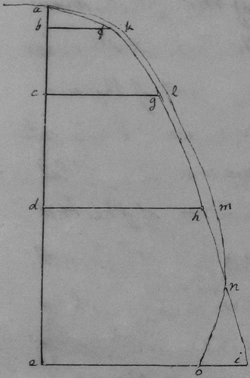
Indulging corollaries on this theory, let us suppose a plane surface, as a large sheet of cast iron let down by a cable from a boat, and made to present it’s surface to the current by a long vane fixed on it’s axis in the direction of the current. would not the current below, laying hold of this plate, draw the boat down the stream with more rapidity than that with which it otherwise moves on the surface of the water? Again at the cross current of the surface, which flows into the Chafalaya, and endangers the drawing boats into that river, as you mention pa. 18. would not the same plane surface, if let down into the under current, which moves in the direction of the bed of the main river, have the effect of drawing the vessel across the lateral current prevailing at it’s surface, and conduct the boat with safety along the channel of the river? The preceding observations are submitted to your consideration. by drawing your attention to the subject, they will enable you, on further reflection, to confirm or correct your first opinion. if the latter, there would be time, before we print a volume, to make any alterations or additions to your paper which you might wish.
We were much indebted for your communications on the subject of Louisiana. the substance of what was recieved from you as well as others was digested together & printed without letting it be seen from whom the particulars came, as some were of a nature to excite ill will. of these publications I sent you a copy. on the subject of the limits of Louisiana nothing was said therein, because we thought it best first to have explanations with Spain. in the first visit, after recieving the treaty, which I paid to Monticello, which was in August, I availed myself of what I have there to investigate the limits. while I was in Europe I had purchased every thing I could lay my hands on which related to any part of America, and particularly had a pretty full collection of the English, French & Spanish authors on the subject of Louisiana. the information I got from these was entirely satisfactory, and I threw it into a shape which would easily take the form of a Memorial. I now inclose you a copy of it. one single fact in it3 was taken from a publication in a newspaper supposed to be written by Judge Bay who had lived in West Florida. this asserted that the country from the Iberville to the Perdido was to this day called Louisiana, and a part of the government of Louisiana. I wrote to you to ascertain that fact, and recieved the information you were so kind as to send me; on the reciept of which I changed the form of the assertion, so as to adapt it to what I suppose to be the fact, and to reconcile the testimony I have recieved; to wit that tho’ the name & division of W. Florida have been retained, and in strictness that country is now called by that name, yet it is also called Louisiana in common parlance, & even in some authentic public documents. the fact however is not of much importance. it would only have been an argumentum ad hominem. altho’ I would wish the paper inclosed never to be seen by any body but yourself, & that it should not even be mentioned that the facts and opinions therein stated are founded in public authority yet I have no objections to their being freely advanced in conversation, and as private & individual opinion, believing it will be advantageous that the extent of our rights should be known to the inhabitants of the country, and that however we may compromise on our Western limits we never shall on the Eastern.
I formerly acquainted you with the mission of Capt. Lewis up the Missouri and across from it’s head to the Pacific. he takes about a dozen men with him, is well provided with instruments, and qualified to give us the geography of the line he passes along with astronomical accuracy. he is now hutted opposite the mouth of the Missouri ready to enter it on the opening of the season. he will be at least two years on the expedition.4 I propose to charge the Surveyor general N. of Ohio, with a survey of the Missisipi from it’s source to the mouth of Ohio, & with settling some other interesting points of geography in that quarter. Congress will probably authorise me to explore the greater waters on the Western side of the Missisipi & Missouri, to their sources. in this case I should propose to send one party up the Panis river to it’s source, thence along the high lands to the source of the Padoucas river and down it to it’s mouth. another party up the Arcansa to it’s source, thence along the highlands to the source of the Red river, & down that to it’s mouth, giving the whole course of both parties corrected by astronomical observations. these several surveys will enable us to prepare a map of Louisiana, which in it’s contour and main waters will be perfectly correct, & will give us a skeleton to be filled up with details hereafter. for what lies North of the Missouri we suppose British industry will furnish that. as you live so near to the point of departure of the lowest expedition, and possess and can acquire so much better the information which may direct that to the best advantage, I have thought, if Congress should authorise the enterprise to propose to you the unprofitable trouble of directing it. the party would consist of 10. or 12. picked souldiers, volunteers with an officer, under the guidance of one or two persons qualified to survey & correct by observations of latitude & longitude, the latter lunar, and as well informed as we can get them in the departments of botany, natural history & mineralogy. I am told there is a mr Walker in your town, & a mr Gillespie in N. Carolina, possessing good qualifications. as you know them both, you can judge whether both are qualified, should two persons go, or which is best, should but one be sent, or whether there is any other person better qualified than either. their pay would probably not exceed 1000. D. a year, to which would be added their subsistence. all preparations would be to be made at Natchez & N. Orleans, & the necessary advances be furnished by the Collector of N. Orleans, on your order. to take this trouble no inducement could be proposed to you but the gratification of contributing to the promotion of science. instructions similar to those of Capt. Lewis would go from here, to be added to by what should occur to yourself, and you would be the center for the communications from the party to the government. still this is a matter of speculation only, as Congress are hurrying over their business for adjournment, and may leave this article of it unfinished. in that case what I have said will be as if I had not said it.
There is such a difference of opinion in Congress as to the government to be given to Louisiana, that they may continue the present one another year. I hope and urge their not doing it, & the establishment of a government on the spot, capable of meeting promptly it’s own emergencies. Accept my friendly salutations & assurances of great esteem & respect.
Th: Jefferson
PoC (DLC); at foot of first page: “William Dunbar esq.” Enclosures: see The Boundaries of Louisiana, printed at 7 Sep. 1803 (Vol. 41:321-40), and Continuation of an Examination of the Boundaries of Louisiana, 15 Jan. 1804 (Vol. 42:280-4).
the chafalaya: Atchafalaya River.
For the published digest of communications on the subject of louisiana, see TJ to the Senate and the House of Representatives, 14 Nov. 1803 (Vol. 41:721).
For the publication in a newspaper attributed to Judge Elihu Hall bay that argued for the inclusion of West Florida within the boundaries of Louisiana, see Vol. 41:327, 328n, 619n.
i am told: TJ probably referred to a missing letter from Andrew Ellicott, dated 27 Feb. 1804, which he recorded in SJL as received on 1 Mch. from Lancaster with the notation “Walker. Gillespie. Ellicott.” John Peter Walker and David Gillespie had assisted Ellicott on his survey of the southern boundary of the United States. After completing the field work, Walker went with Ellicott to Philadelphia to assist in preparing the maps of the expedition’s findings. Returning to Natchez by 1802, Walker subsequently worked as a surveyor and mapmaker for the Spanish government in Louisiana, Texas, and Mexico (Elizabeth A. H. John, “The Riddle of Mapmaker Juan Pedro Walker,” in Stanley H. Palmer and Dennis Reinhartz, eds., Essays on the History of North American Discovery and Exploration [College Station, Tex., 1988], 102-32; Vol. 42:378, 379n; Dunbar to TJ, 13 May; Appendix II).
1. Preceding six words interlined.
2. Word interlined.
3. Preceding two words interlined.
4. TJ here canceled “I believe Con.”