
From John Jay to Grenville, 4 September 1794
To Grenville
[Royal Hotel—pall mall, 4 Septr. 1794—]
Mr. Jay presents his respectful Compliments to Lord Grenville, and requests the favor of his Lordship to name a Time for recieving Mr. Jay, on the Subject of the proposed Treaties. In the mean time, Mr. Jay has the Honor of submitting the Remarks herewith enclosed, to His Lordships Consideration—1
Remarks on that Part of the second Article of the Project of a Treaty for terminating all Differences between Great Britain and the united States of America, which purports a Cession or Dereliction, by the latter, of the Country lying to the westward and northward of either of the two Lines therein proposed & described.
For this cession or Dereliction two Reasons are assigned, vizt.
1st. That it is now understood that the River Mississippi would in no part thereof, be intersected by a west Line from the Lake of the Woods.—2
2dly. That it was stipulated by the Treaty of Peace, that the navigation of the River Missisippi should be free to both Parties—
Admitting the Fact mentioned in the first of these Reasons, to be well founded, it shews only that the northern and western Lines of the United States do not meet and close—and therefore, that it is necessary to fix on a Line for closing them. But no argument thence results, that either Great Britain or the united States, ought to cede or acquire any Territory further than what such closing Line may possibly render unavoidable.
That the Missisippi would in no point thereof be intersected by a west Line from the Lake of the Woods, is a Fact involved in too much uncertainty to be assumed as a Foundation for national Stipulations; for however it may be conjectured or supposed, yet it still remains to be ascertained.
The map sent to Mr. Jay by Lord Grenville—vizt. Faden’s, published in 1793—3 informs us, that the River Missisippi has been ascended only as far up as about the 45 Degree of north Latitude, that is about a Degree above the Falls of St. Anthony— so that its further Extent and Course towards the north, are yet to be discovered.
On the same map, Faden lays down a Stream connected with the marshy Lake, near the 45 Degree of Latitude; and thus denominates it “The Missisippi by Conjecture”.
He also lays down on the same map a Stream connected with the white Bear Lake, near the Latitude 46, and thus denominates it “The missisippi by Conjecture.”
He also lays down on the same map a Stream connected with the Red Lake, in Latitude 47, and thus denominates it “Red Lake River, or Lahontan’s Missisippi.”
Inasmuch therefore as three different Streams found in the immense wilderness above Latitude 45, are conjectured to be the Missisippi, it is plain, that so far from being certain how far that River runs to the north, we really are yet to learn where it does run, and which of the Rivers in that wilderness it is. How then can it be assumed as a Fact, resting on good Evidence, that the Missisippi would at no Point thereof, be intersected by a west Line from the Lake of the Woods?
Individuals differing about Boundaries depending on the course and Extent of Brooks or Streams, settle questions of that kind by actual Surveys. States usually and with good Reason do the same— Why be content with delusive conjectures and Probabilities, when absolute certainty can easily be had. Let a Survey be accurately made by joint Commissioners, and at joint Expence. The united States are ready to adopt that measure, and to enter into the necessary Stipulations and arrangements—
If it should appear on such a Survey that the West Line would intersect the Missisippi, no Room for further questions or Dispute will remain— but if the contrary should prove to be the Case; then, as the northern and western Lines of the united States would not close, the manner of closing them will naturally and necessarily come under Consideration. Several modes of closing them may be devised; neither of which may be altogether agreable to both Parties— unless they shall be able to agree, let joint commissioners at joint Expence, and upon oath, fix a closing Line, in the manner which they shall judge most consonant with the true Intent & meaning of the Treaty of Peace.— The united States are ready to enter into such eventual Stipulations as may be necessary for that Purpose.
The second Reason assigned for this cession is “that it was stipulated by the Treaty of Peace, that the Navigation of the Missisippi should be free to both Parties.”— From this Stipulation it is argued, as a natural and necessary Inference, that it was in the Expectation and Intention of the Parties that they should and would both border, not only on the River, but also on the navigable part of it—
This Inference seems to be violent. a Right freely to navigate a Bay, a Straight, a Sound, or a River is perfect without, and does not necessarily presuppose, the Dominion and Property of Lands adjacent to it.
But altho from a Right to navigate the River Missisippi, a Right to adjacent Lands cannot be inferred, yet when that Right is connected with the
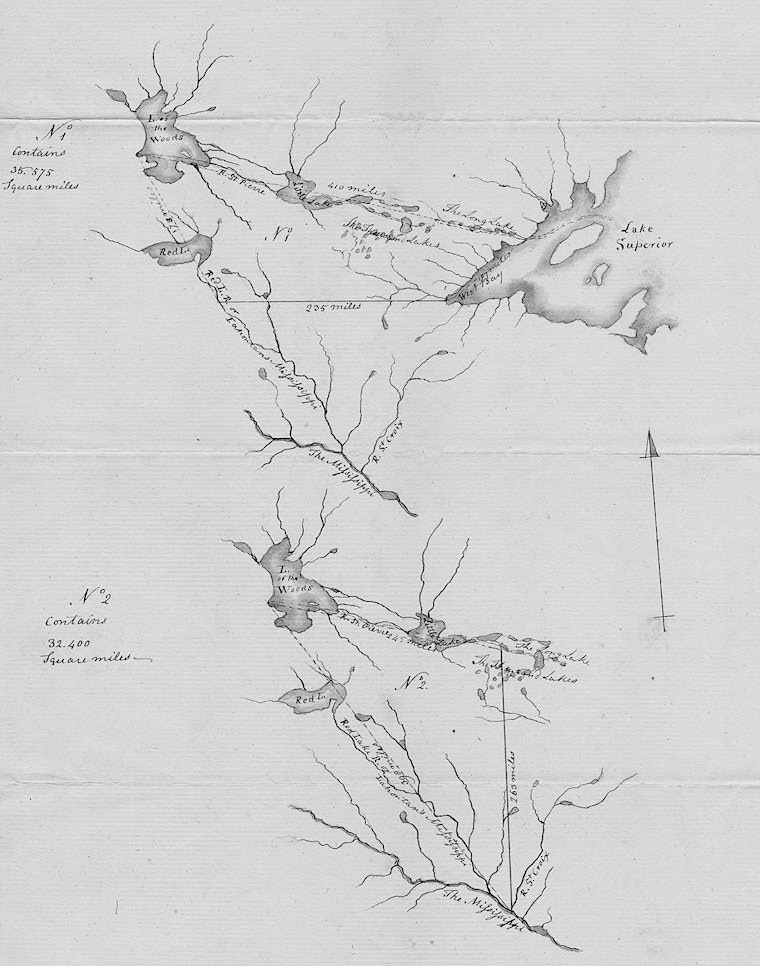
Two maps of the northwestern boundary of the United States accompanying JJ’s 4 September 1794 objections to Grenville’s projets of 30 August 1794, draft or file copy by John Trumbull. (Rare Book & Manuscript Library, Columbia University in the City of New York)
They might, or they might not, have expected & intended it.— whether they did or not, can only be discovered from their concomitant words and actions.
On looking into the Treaty for words indicating such Intention our Search proves fruitless— there are no such words in it; not the least Shadow of a Stipulation or Declaration on the Point.
If we review the Plan and manifest Design of the Treaty relative to Boundaries, we find the Idea of such Intention uniformly contradicted.
The Treaty in delineating the Boundaries of the United States, passes from the northwest angle of Nova Scotia, to the Head of Connecticut River—then down that River to the 45 Degree of Latitude—then on that Line of Latitude to the River Iroquois, there (quitting that Line of Latitude) to Lake Ontario—then from Lake to Lake, thro’ their connecting waters, untill it arrives at the Lake of the Woods, and passing thro’ it, to the north westernmost point thereof, proceeds on a due West course to the Missisippi &c. &ca.
now it was always well known, and the maps shew it, that the Lake of the woods is situated at a great Distance in the North above the Latitude of the Falls of St. Anthony, which interrupt the navigation of the Missisippi; and consequently that a due west Line from the Lake of the Woods, must of necessity strike the River above those Falls; & as far above them, as the Latitude of the Lake, is above the Latitude of the Falls.—
Again—It was not then known, nor is it yet known, how far the Missisippi runs navigable beyond those Falls— nor whether any, or how many other Falls intervene between them and its Source. The Parties therefore, being entirely ignorant of the Extent, and of the course, and of the character of the River high above the Falls, could not possibly have judged, or divined or guessed, whether the Place or Part of the River, at which the west Line would strike it, was navigable or not— How then could they expect or intend any thing about it?— nothing could be more obvious, than that a due west Line might terminate on the River at a Place not navigable; and had Navigation been in View, it seems strange that the Treaty should not contain a Provision, that if the said west Line, on being actually run, should strike the River at a Place where it was not navigable, that then the said Line should be inclined so many Degrees Southerly, as might be necessary to bring it to the first navigable water of the River. Yet nothing like this is to be found in the Treaty—
It is not difficult to discern from the Treaty, and so was the Fact, that other Ideas and Views governed the Direction of the Boundary Lines.
The Question then was, where would it be most convenient to both Parties; and all Things considered, where would it be most wise & prudent that the Boundaries between them should be fixed?
Two Lines were proposed and considered, one from the Point before mentioned on Connecticut River and running straight on the Line of the of 45th. Degree of Latitude, west to the Mississippi— The other was the one adopted and established by the Treaty—
The official Papers of the ^british ministers^ which respect that Negotiation will probably shew, that Great Britain had the choice of these two Lines, and that she preferred the latter— this choice and Preference gives no Support to the Idea that she then contemplated navigable water in that part of the Missisippi which was supposed to penetrate into Canada. The first Line if adopted would have favored it, and fair Presumption might have classed that among the Reasons of Preference. But notwithstanding this Great Britain did not prefer it— on the contrary, as the waters would form a Line which could never be mistaken, and afforded great conveniences to both Parties, the Line of the waters was preferred by both.
This water Line was by mutual consent terminated at the northwestern-most Point of the Lake of the Woods. It was agreed that the Missisippi should bound the United States on the west— nothing then remained but to agree on the course, which the closing Line from that Lake to the River should run; and a due west course was agreed upon, without any Expectation or Design that it would or should there meet with navigable water.—
The Truth is, that the Stipulation respecting the navigation of the River being free to both Parties, was an after thought; & gave Occasion to a new and Subsequent article, vizt. the 8th.—
Even on the drawing that article, when the navigation of the River became an object of Contemplation; no Connection was introduced between the Right mentioned in that article, and the Boundaries designated in the second article— no Facilities were asked or proposed or stipulated for a water or any other Communication between Canada & the navigable water of the Missisippi; which doubtless would have been the Case, had such a communication been then in View; especially considering the absolute uncertainty, and extreme Improbability, of that River’s being navigable above the high Latitude of the Lake of the woods.
From the beforementioned Circumstances and Considerations it seems fairly to result that the two Reasons assigned for the cession in question as a matter of Equity and Right, do not afford it a solid Foundation—
If this conclusion be just, it precludes, the necessity of shewing at large, that none of the Inferences ascribed to the said two Reasons, involve a Claim to Tracts of Country so extensive as either of the two proposed and marked on the map— each of which includes more than thirty thousand square miles—and that without taking into the Computation the extensive Country lying between (what in the subjoined Diagrams are for the purpose of computation regarded as) the West Sides of these Tracts and the Missisippi, and to the Southward of the West Line from the Lake of the Woods, and which Country would on either of the proposed Plans, also become annexed to Canada—4
AD, with two maps by JT, UK-KeNA: FO 95/512 (EJ: 05000). Endorsed. C, in JT’s hand, with maps, DNA: Jay Despatches, 1794–95 (EJ: 04316); C, unknown repository, formerly PRO (EJ: 03994); C, NHi: King (EJ: 04448); LbkC, in JJ to ER, 13 Sept. 1794, NNC: JJ Lbk. 8.
1. For JJ’s immediate rejection of what he considered Grenville’s proposed cession of a significant area north and west of the headwaters of the Mississippi, see JJ to Grenville, 1 Sept. 1794, above; and Grenville to JJ, 5 Sept. 1794, below.
2. In the course of peace negotiations with Richard Oswald in 1782, JJ had claimed that there was water carriage from Canada to the mouth of the Mississippi. See , 3: 184.
3. See William Faden, “The United States of North America with the British Territories and those of Spain according to the Treaty of 1784” (London, 1793). American Memory http://hdl.loc.gov/loc.gmd/g3300.ct001218 (accessed Oct. 2018). Faden (1749–1836), a cartographer, served as royal geographer to George III.
4. For his report on this issue, see JJ to ER, 13 Sept. 1794, below.