
Thomas Jefferson’s Labeled Diagrams Related to Calculations of Altitude of the Peaks of Otter, [ca. 10–17 November 1815]
I. Labeled Diagrams Related to Calculations of Altitude of the Peaks of Otter
[before 10 Nov. 1815]
to obtain the altitude a.b. from 2. stations c. & d. each in the plane of the axis of a mountain a.b. and themselves on an inclined plane.
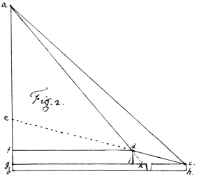
a. the apex, or summit of the mountain.
a.b. it’s Axis. b. it’s base in the level of a river.
c. the plane of the instrument at it’s 1st station.
d. it’s plane at it’s 2d station.
c.d. the inclined plane measured.
de. the same continued to the axis at e.
df. the horizontal plane in the level of d.
cg. the horizontal plane in the level of c.
ch. the height of the instrument above the surface of the river in b.h.
di. the height of the instrument at d. above the level of c.g.
dk. continuation of ad. to the plane of c.g.
| at c. | observe | the vertical ∠ acg. and rhumb of c.g. |
| and the height of the instrument above the water, to wit, ch. | ||
| the vertical ∠ icd1 | ||
| measure | c.d. | |
| at d. | observe | the ∠ of altitude a.d.f. |
| In the △ cdi. | to reduce cd. to ci. to find di. and c.i. |
| given cd and all the angles | |
| in the △ dik. | to find i.k. in order to reduce c.i. to ck. (given di. & all the ∠s) |
| in the △ ack. | to find ak. (given ck. and all the ∠s) |
| in the △ akg. | to find ag. and gk. (given ak. and all the ∠s) |
| to ag. add ch. or gb. for the whole altitude ab. | |
To ascertain the height and distance of an inaccessible object (e.g. the summit of the sharp, or South peak of Otter) by a measured base between two stations on an inclined plane, nearly parallel with the mountain.
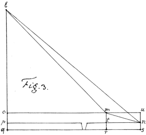
let l. be the apex, or summit of the mountain.
q. a point in it’s axis in the level of it’s base q.r.s & of the surface of Otter river
m. the plane in which the instrument is placed at it’s 2d and highet2 station.
n. it’s plane at the 1st3 or lowest station.
m.n. the inclined plane measured from station to station.
m.o.u. the horizontal plane of m.
n.t.p. the horizontal plane of n.
m.t. the difference of level between these two planes
m.r. the height of m. above the base, or water of the river.
| l.o.p.q. |  |
are vertically coincident. then |
| m.t.r | ||
| u.n.s | ||
| m.u.o | |
are 3. horizontal △s vertically coincident, & consequently similar & equal. |
| t.n.p. | ||
| r.s.q. |
in this figure the line p.n. is assumed longer than o.m. that it may project in the profile, & shew in perspective the parallelograms m.u.s.r. & m.u.n.t. the diagonal m.n. & △ l.m.n.
| at m. | observe | the vertical ∠s l.m.o. & u.m.n. |
| the horizontal ∠ o.m.u. & rhumbs of m.o. & m.u. | ||
| the height of m.r. | ||
| [the altitude, horizontal ∠ & rhumb of the summit of the North peak L. for another object] | ||
| measure the inclined plane m.n. | ||
| at n. | observe | the vertical ∠ l.n.p. |
| the horizontl ∠ t.n.p. & rhumb of n.p. | ||
| [the altitude, horizontal ∠ & rhumb of the summit of the North peak L.] | ||
with these data proceed as follows.
to reduce n.m. to n.t. = u.m. & to find m.t. in the △ m.n.t. given m.n. & all the ∠s
| to find t:p = m.o. and n.p. | in the horizontl △ n.p.t. given n.t. & all the ∠s |
| to find l.o. | in the vertical △ l.m.o. given m.o. & all the ∠s. |
| to find l.p. | in the vertical △ l.n.p. given n.p. & all the ∠s. |
add l.o. to o.q. and l.p. to p.q. and take the mean for the true height l.q.
The observations of the North peak from m. and n. may be used to obtain the distance between the two peaks, according to the diagram & method of Fig. 1. page 1. by reducing m.n. to t.n. which will then correspond with a.b. there, as c.d. there will correspond with l. and L. in these observations.
MS (MHi); filed with TJ’s Weather Memorandum Book, 1802–16; written entirely in TJ’s hand on two sheets of paper, with recto of unnumbered first page containing related theoretical mathematical exercises and two unnumbered figures in TJ’s hand (omitted here) for ascertaining the distance and altitude of inaccessible objects from known points and calculating the bearing and distance from each other of inaccessible objects; undated; brackets in original.
1. Reworked from “acd.”
2. Thus in manuscript.
3. Reworked from “2d.”