
Thomas Jefferson to William Short, 28 February 1816
To William Short
Monticello Feb. 28. 16.
Dear Sir
Having procured an appointment for the 21st inst. the Surveyor, arbitrators, parties (by their agents) and witnesses met. the forenoon was showery but the difficulty & uncertainty of all collecting again from different parts of the county induced all to go thro’ the work. the Surveyor run the lines,
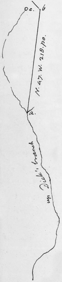 and instead of something less than 30. as as had been conjectured, he found them to contain 68. as. this proceeded from a great bend of Dick’s branch as it went up the mountain which had been expected to be nearly strait. mr Carter had considered the place (a) in the1 diagram of the margin as the head of the branch, & had run your line from a. to b. he might have been decieved by the sinking of the branch as it does in several places, but reappears again, so that it exists distinctly up to the spring at c. near the gap of the mountain. the arbitrators decided that to be the head of Dick’s branch, and the branch itself to be the line. mr Higgenbotham therefore will deduct 680.D. from his last payment. according to former opinions and some decisions, mr Carter would be bound to pay you that sum. but I understand that according to the law as now established, he is liable only for the original sum he recieved, 23/6 per acre, and interest on that to the present day. this brings it to about 8. Dollars an acre so that you will recieve 2.D. an acre less on the whole for these 68. acres than for the rest. mr Carter, who conducted us himself along the line to which he said he had sold to Colo Monroe had certainly been too careless in examining the ground before. the first time we went on it to examine, it was evident that Dick’s branch formed the main division between the two mountains. every person present concurred in the opinion of the arbitrators. they divided costs, which will be about 6. or 7. Dollars apiece to you. I salute you with constant & affectte respect.
Th: Jefferson
RC (ViW: TJP); at foot of text: “Mr Short”; endorsed by Short as received 9 Mar.
The surveyor was William Woods.
A 25 Jan. 1816 letter from Short to TJ, not found, is recorded in SJL as received 31 Jan. 1816 from Philadelphia.
1. TJ here canceled “plat.”
Index Entries
- Albemarle County, Va.; surveyor of search
- Carter, William Champe; and Highland–Indian Camp boundary dispute search
- Carter, William Champe; and W. Short’s land search
- Carter, William Champe; J. Monroe’s debt to search
- Higginbotham, David; and Highland–Indian Camp boundary dispute search
- Higginbotham, David; and W. Short’s land search
- Highland (J. Monroe’s Albemarle Co. estate); boundary dispute search
- Indian Camp (W. Short’s Albemarle Co. estate); boundary dispute search
- Jefferson, Thomas; Business & Financial Affairs; and Highland–Indian Camp boundary dispute search
- Jefferson, Thomas; Business & Financial Affairs; and W. Short’s property search
- Monroe, James; and Highland–Indian Camp boundary dispute search
- Monroe, James; land surveyed search
- Short, William; and Indian Camp search
- Short, William; letters from accounted for search
- Short, William; letters to search
- Woods, William (ca.1777–1849); and Highland–Indian Camp boundary dispute search